Eagle Creek Dry Storage Basin
The Eagle Creek Flood Basin is a flood-risk reduction project designed to have storage capacity for excess flows from the 1% Annual Chance Exceedance (ACE) (100-year) storm event on Eagle Creek and to safely pass flood events of greater magnitude. The basin will remain dry during normal flows (up to approximately 650 cubic feet per second along Eagle Creek) and will begin to store flood waters during larger rain events. The purpose of the project is to reduce the peak flow rate in Eagle Creek and the Blanchard River during these large storm events, thereby reducing the downstream water surface elevations and associated flood risk. The primary project goals include the following:
- Reduce water surface elevations during flooding events along Eagle Creek and the Blanchard River; and
- Reduce flood risk to mitigate potential structural, social, and environmental damages.
A secondary project goal is to improve water quality by creating wetlands, native habitats, and riparian corridors within the inundation area. A tertiary goal is to provide passive recreation opportunities on the project site.
The project site is located in Eagle Township in Hancock County, Ohio, approximately four miles south of the City of Findlay downtown area.
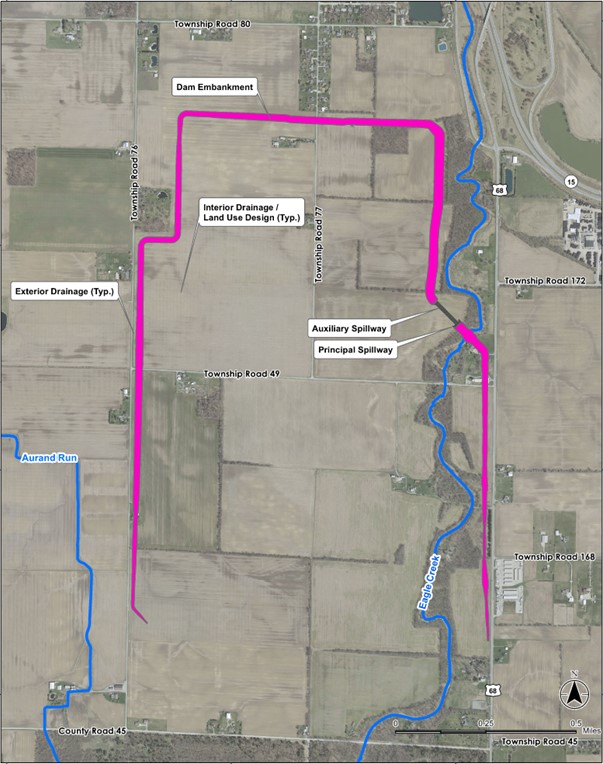
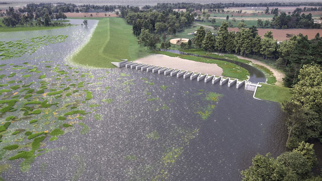
The primary flood risk reduction element for the project is an earthen embankment dam forming an in-line, dry-storage basin. Other primary components consist of a principal spillway, an auxiliary spillway, exterior drainage features, and interior drainage improvements and land use design. The dam alignment and proposed dry basin footprint is bound by Township Road 76 to the west and US-68to the east. To the north, the basin is formed by an embankment parallel to and approximately 4,000 feet to the north of Township Road 49. The impoundment is bound by high ground to the south, approximately 1,750 feet north of County Road 45. The impoundment area of the basin within the dam alignment will be approximately 765 acres.
The Eagle Creek Flood Basin project is being funded by Grants through Ohio State Capital Budget. Grants of $60 million have been received to date. The estimated annual maintenance cost is approximately $100,000 to $150,000. Additional funding sources are being explored to cover rising labor and materials costs. FEMA funds are being pursued to complete the funding mechanism for this project. If a FEMA grant is awarded, the project could be delayed by up to 2 years to allow for FEMA’s project review and environmental site assessments.
To date, the project has progressed through Final Design. Property acquisition is ongoing, and stakeholders are in the process of obtaining necessary easements and permits before moving to the construction phase. The project will require a construction permit through the ODNR Division of Water Resources Dam Safety Program. Tree clearing was performed as part of a separate contract in February 2024 project to comply with permitting restrictions. Construction duration is approximately 18 to 24 months. The start of construction is dependent on many factors including ongoing grant pursuits.
Project Benefits:
Model results show that the Eagle Creek Flood Basin project results in a peak flow reduction of about 2,550 cfs (16% decrease) on the Blanchard River during the 1% ACE event which translates to about 2.2 feet of lowering of the base flood elevations near the confluence with Eagle Creek.
The reduction in water surface elevations along Eagle Creek and the Blanchard River is estimated to remove approximately 1,830 parcels and 1,400 acres from the regulatory floodplain.